Saturday July 2, 2011
We woke up early to leave the house at 8am for the ferry to the Olympic Peninsula to get up close and personal with the mountains. We rented a minivan for the weekend to comfortably (and legally) seat 4 adults and 2 children in car seats. Chance came along with us so we didn’t have to rush back home to let her out. The fastest way there from our house is to take a ferry from Edmonds to Kingston because it avoids driving all the way south around the Puget Sound near Tacoma. It saves at least an hour without traffic, but you still have some wait time at the ferry terminal. You can buy tickets and reservations ahead of time, but loading the ferry with cars is a first come, first serve. The traffic line waiting to aboard the Edmonds ferry was backed up all the way past City Park, about a mile from the gate to pay and load. We didn’t get to the back of the line until the 8:50am ferry was leaving port. We ended up on the 10:30am ferry to Kingston, virtually straight across the sound. It is a 30 minute ride over.
Straight ahead, were the majestic Olympic Mountains, our destination. 


Another ferry passed by.

To the north, near Bellingham, Mount Baker was out in all its glory, ready to be seen from this far south. She was visible above Whidbey Island, which we were viewing last weekend from Mukilteo Lighthouse Park (we’ve also been to this island in April to visit Deception Pass State Park).


From the ferry looking south we could see some high-rise buildings in downtown Seattle and I think I could make out the Space Needle.
After snapping a few photos of the Lee’s, I finally noticed a mountain I had not seen before….Mount Rainier. I immediately dialed Joe on the phone (he was on the car deck checking on Chance) to see if he’d seen the mighty mountain. I feel like every photograph of both Mount Baker and Mount Rainier are always doesn’t do it justice since the white snow-cap often blends into the light blue sky. Hopefully you understand how excited I was to see this.


The funniest part of this ferry ride was some clueless guy running around the car deck as we pulled into port asking if “Anyone seen a red mazda?!?” Apparently this driver couldn’t recall where he left his car and would be holding up the de-boarding process if he didn’t find it quickly.
From Kingston we drove about an hour to Port Townsend to grab a bite to eat for lunch. Shortly after passing Port Gamble on Hwy 104, we had to cross the Hood Canal on the floating bridge which was NOT something Chance enjoyed. The rumble noise of the car going over grates or segmented roadways really scares her. She tried to climb underneath her dad’s feet while he was driving! Fortunately I corralled her in front my front seat to try and calm her down. Poor thing is such a wuss.


The GPS didn’t exactly take us to city center, but we ended up finding uptown’s farmer’s market this way. We walked through the strange crowds looking for a good food stand. While the kids played at a community playground and the family ordered wood-fired pizzas, I took a walk down to the waterfront to take in Port Townsend.

Joe was just ready to get to the mountains by now and his family didn’t care about seeing the Victorian architecture like the nerd I am so I went alone (and probably covered a whole lot more ground this way).


The Bell Tower was built in 1890 to call volunteer fire fighters to their posts. It is the only known tower of its kind in the US. From here there was an amazing view from upper Port Townsend toward the Cascades.


Here is a clock tower and the Olympic Mountains.


Port Townsend has a great waterfront.


I had picked out a highly recommended Thai place for lunch since the kids only eat Chinese food (give them some rice and they’ll eat). The GPS took us to the wrong location in uptown (she kept doing circles having a hard time accurately locating us), but at least I have it noted down for our next visit: Khu Larb Thai.

While we loaded up in the car, Chance decided she wanted to be our driver.

Next time I’d like to visit Fort Worden State Park.
The stop in Port Townsend was a little out of the way, but worth it in my book. We had an hour drive to Hurricane Hill in the Olympic National Park. We connected with Hwy 101, the Pacific Coast Scenic Byway. We drove west toward the Pacific Ocean along the international waters of Juan De Fuca Strait through Sequim, known for its lack of rainfall in the Olympic rainshadow and its lavender fields.
In Port Angeles, we turned north toward the Olympic Mountains into the Olympic National Park. We drove toward Hurricane Hill where I planned for us to hike. We stopped at the Olympic National Park Visitor Center to check on the trail status and make sure the road to it was open. The ranger showed us a camera view of how busy Hurricane Ridge was. It is the most popular spot in the park due to how accessible it is. She really had me worried when she said the Hurricane Hill trail was not paved even though 3 of my tour guidebooks had said it was. She let us know that there was a good bit of snow covering over the middle section of the Hurricane Hill trail. With all the snow this season, it hasn’t melted yet on the north side of the mountain. Since we had a 2 year old in a stroller and some of the family were wearing flip flops we decided that this trail was probably not our best option this trip. Upon closer inspection of the map from the ranger, it is a paved trail so it still is a good 1.5 mile one way hike up 660’ along the Hurricane Ridge for a later this summer. We decided stop at the large parking area on Hurricane Ridge and walk over to the overlook toward the Juan de Fuca Strait.
We bought an annual pass at the gate to the Olympic National Park for $30 since this probably isn’t our last time here (its $15 a day). We debated getting the $80 annual pass to all the national parks, but weren’t sure if we’d end up visiting all the others often enough to make it worthwhile. Hopefully the trail hikes in the North Cascades we want to do won’t be on national park grounds so we can avoid some fees there. Now we wish we had bought it at the Grand Canyon back in March.
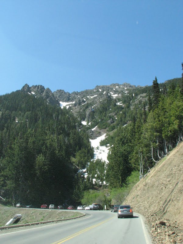
The drive up Hurricane Ridge Road/Heart O the Hills Road was beautiful. Within 17 miles, we climbed up close to 5,000’ in elevation. We went through a mountain tunnel.

There were overlooks of the snow-capped mountains. I was not expecting to be driving up amidst hills still covered in snow! It’s July 3rd and there is snow all over the place!


As we drove into the parking lot area, a black-tail deer was crossing the pavement with people only 8 feet away snapping pictures. The view was amazing with the deer grazing on the nearby slope.


The video at the bottom of this post will give you a better idea of the panoramic view.


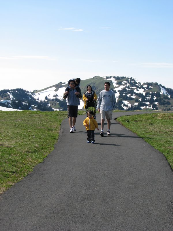
The path to the overlook was free of snow, but there was still some on the surrounding grass meadow and hillsides. I’m glad I wore my waterproof hiking boots so I could run through the snow all I wanted! There was a sign on the edge of the hillside that read “Caution Avalanche Area.”

From the overlook we had an international view of Port Angeles, Strait of Juan de Fuca, Vancouver Island, Salt Spring Island, Victoria, Haro Strait and San Juan Island to the right.


Zachary enjoyed a small snowball fight.


This is a great picture of dad & son.


Great one of the family.


One more.

Joe was using Zachary as a broom sweeping up the snow. He thought it was hilarious.


Joe loves to torture children.


The family walking on the trail.


Doesn’t it look like Joe’s trying to force him down the cliff? Something tells me he’s not ready to be a dad yet ;)

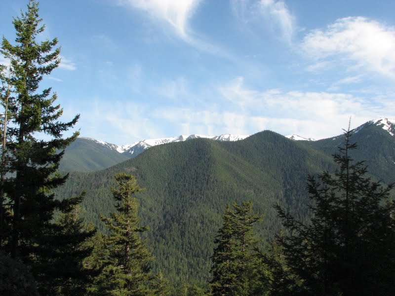
More great photos of the snow-capped Olympics Mountains.


Seriously I think Joe’s just trying to find a way to get rid of the kids now.


Deer grazing.


Joe took some great photos of me with the deer grazing and the Olympics in the background. I think I see a new profile picture on Facebook coming soon.


I had Joe drive up the mountain a little further to the Hurricane Hill trailhead. Half of the parking lot was covered with feet of snow and there were cars parked everywhere possible. It’s clear this hike is well worth it based on the popularity. We will be back and hopefully we’ll see Mount Olympus (the Olympic mountains highest peak) at a better vantage point further west down the trail.
Driving back down the mountain there were many overlooks where I snapped pictures.


We drove down the mountain and filled up on gas before heading to Sequim for dinner. We ate Thai. An hour later we were at the ferry terminal in Kingston with a minimal wait to pay & park for the next ferry to load.
On the ferry ride home we could no longer see Mt Rainier beyond Seattle after the sunset. The colors in the sky are a beautiful backdrop against the islands.


The video of the panoramic view of the Olympic Mountains from Hurricane Ridge.
No comments:
Post a Comment