We knew we wanted to go camping this weekend since next weekend I’m taking an ARE and the weekend after that we’ll be in Wisconsin to visit family. We wanted to go back to the Olympic Peninsula, but early in the week it looked like it was going to rain out there while it was still nice by us so I researched the Cascades for a good bit. When I let Joe know on Wednesday that a lot of the top hikeson my list to do were still snowed in due to the record amounts of snow this winter, so he noticed that the weather for the peninsula had shifted and was supposed to be nice as well. This weekend turned out to be the best summer weather we’ve had yet. We actually got HOT, breaking 80!
Many of the campgrounds on the Peninsula are first-come, first-served. Our plan was to leave early Saturday morning and hope to find an available campsite. I had my top 4 eastern north peninsula campgrounds chosen. After we got off the ferry from Edmonds to Kingston I started calling the campgrounds, but each were saying they were full! We decided to test our luck at my top-ranked campground, the Dungeness Recreation Area. Our hope was that some people were checking out that morning. Half of the campsites can be reserved, but it must be done 2 weeks ahead of time. The other half were first-come, first-served.
As we drove closer to the shore, the foggy mist became denser and denser. We could barely see 40 feet in front of the car.It was very strange weather. When we made our turn onto Kitchen-Dick Road I couldn’t stop laughing, especially when the prim-and-proper GPS said the name of the road. But what really got me going was passing the intersection of Kitchen-Dick Road and Woodcock. That’s right, read that again. Kitchen-Dick and Woodcock.
We drove by the entrance where we assumed we’d check in with the ranger, but no one was at the building. We circled through the campground and called the campground again to figure out the process and availability. They told us to go back to the kiosk at the entry to register. You grab an envelope, drive-by the loop of unreserved campsites hoping to find one open. Then you leave your car at the site, quickly fill out the envelope with your chosen campsite number and payment and get back to the registration kiosk before another person has officially claimed your site by paying first. We were extremely thankful to a couple that stopped and explained this process to us, which they had been confused about on Thursday when they arrived.
We were extremely fortunate to find a campsite that was fairly private and had a great flat spot near the firepit and picnic table for our tent. We setup camp getting the tent, sleeping mats, inflatable pillows and sleeping bags setup for the night. We chose to do the 2 hikes further away for the day since there was a haze of fog hovering here on the coast.
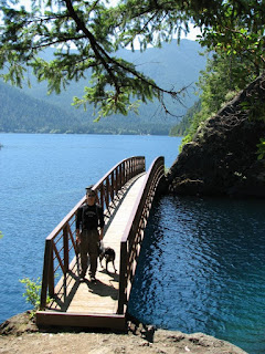
We went to the furthest one away first, the Spruce-Railroad Trail. As soon as we caught a glimpse of the crystal blue waters of Lake Crescent, we knew it was going to be a good hike. The unfortunate part is most of the trails in the National Park don’t allow dogs due to the large wildlife that dogs would threaten to attack. When we got to the trailhead, Joe read the sign about the trail. I knew it was the only National Park trail you could mountain bike, but now it was one of 2 you can take pets! Chance got to join us for this relatively flat hike along the shoreline of Lake Crescent.
The Spruce-Railroad Trial follows an old 36 mile rail line bed built during WWI to transport Sitka Spruce from the forests to the port to build airplanes. Ironically the Great War ended days before the railroad was complete, but it served commercial logging purposes until the early 80’s. Lake Crescent is 9 miles long and 600 feet deep, surrounded by steep ridges and peaks, which makes it seem more like a fjord. The waters are so crystal clear, you can see into 40 feet depths.
We took a little path off the main to see a little clearing on the shoreline. We had never seen lake waters this turquoise blue before except for in the hot Caribbean climates. The blues were constantly changing. It seemed every time I finally had my photograph framed in my camera view the turquoise blue would change to a darker blue color, but it seems we still snapped a few good pictures.
Since no one was around except motor boats fishing and pulling kneeboarders, we decided to let Chance off her leash so she could swim if she wanted.
Joe waded in the water, contemplating swimming. Him and Chance seemed to have a great time.
We sat here on the driftwood logs to have our sandwiches and snacks for lunch in the most serene setting we’ve been in awhile. It was hard to head back to the trail, but we were optimistic for better sights ahead.
There are these things calledbanana slugs secreting mucus all along the trail. They are native to North America’s Pacific coastal coniferous rainforests and redwood forests.
We hiked to the most scenic section of the trail, Devil Point and Punchbowl, about mile 1 from the trailhead. There was a bridge that crosses the Punchbowl. The waters here where amazing.
Joe decided to climb a large rock next to the Punchbowl to get an aerial view of Lake Crescent and the peaks beyond. Somehow Chance found a way to untie herself and try to follow him up the rock. Thankfully she gave up and sat by me.
We turned around here since we still had another long hike left to do. Even from far away, our lunch spot was enticing.
As we hiked back to the car we passed a lot of families on bikes and in bathing suits. I’m glad we came here when we did for a peaceful hike along tranquil waters.
We drove to our next trailhead, the natural Olympic Hot Springs. We passed by the Olympic National Park ranger station, making our annual pass worth it already. The Elwha River was roaring. The lakes in the river valley are slowly being drained (Lake Crescent is not one of them) to prepare for demolishing of the Elwha Dams that have prevented the once prolific salmon to naturally run to Port Angeles. Fish ladders at the dam would not be sufficient here since the temperature of the lakes gets so high that disease spreads rapidly among the spawning fish. This will be the nation’s largest dam removal, starting in September this year. There were even white-water rafters out on the rapids.
The trail to the natural hot springs is a 2.5 mile hike. The trail signs warn of bacteria and how nudity is common, but that the park doesn’t condone this. As we hiked and saw the type of people hiking back in bathing suits, we hoped there wouldn’t be any nudity. The sight of that much flabby skin was enough.
A resort used to exist here until 1966 when their lease expired. The National Park tore down all the buildings and turned it back into a natural setting. The “trail” was the old roadbed into the old resort so it was just wide enough for 2 cars to pass one another. It has been mulched to be as natural as possible, but due to the clearing for the road, we were in the sun for most of the hike. The hike there was gradually uphill, which we didn’t realize until the walk back, which was a lot more relaxing and not just because of the relaxing nature of the hot springs. We were really hot and wishing we could dip into a cold spring first!
There were several waterfalls and the consistent sound of rushing water in the Elwha River Valley as we hiked.
Next to a waterfall, there was a river crossing on a sawn in half log with a rickety “railing” to aid you if you lack the balance. As soon as we crossed I said to Joe, “well it looks like we’re not taking your parents here” because his Dad is afraid of heights. Our last experience with natural hot springs was on the Nanshih River shores in Wulai, Taiwan in 2009 where the waters were almost scolding hot. I would have loved to bring Joe’s family here in Washington. Asians love the medicinal qualities of hot springs. There was even an old style out house along the trail.
We crossed another bridge, this one of more stable wood, where we saw several girls taking a dip in the flowing waters of the river. We were so hot by then, we probably would have enjoyed the swim.
The hot spring pools were natural with stacked stones, mucky waters, mud bottoms and extremely sulfurous. The temperatures range from 85 to 105 degrees. The water seemed to be constantly moving so we didn’t worry about the sanitary experiences, which are more prominent in the summer months with less water flow but the still melting snow probably helped here. The smell of sulfur was present. We both were really glad to have our waterproof hiking boots so we didn’t have to worry about walking in ½” pools and streams of water. We walked by several of the hot spring pools, looking for an empty one for ourselves. Joe stepped out to a clearing to look down to the river below and saw a nude woman staring back at him in a hot spring below. We both quickly turned around to find a more suitable pool for us. I'm sure Joe was happy to see some boobies.
We eventually found a hot spring on the hillside that was about a foot deep. The water was maybe 90 degrees, similar to the temperature of a hot tub. I slowly dipped in my feet. Joe was still so hot that he said he was not going to get in. I had to convince him that he was crazy to hike all this way just to look at the hot springs. He eventually decided to put his feet in when he realized I was in no rush to get out. I’ve had issues with my Achilles tendon for a few years now, and all this hiking in boots has really made them sore. The dip in the hot springs helped soothe my muscles for the hike back to the car and the 2 hikes tomorrow. I can only imagine how great the hot springs would feel on a cold fall/winter day.
Due to the sulfur smell now covering me to my knees, we decided to dip into the river to rinse off. Joe really wanted to go for a swim and cool off. He went in first while I snapped photos. It was cold! A lot colder than the 2 of us thought!
Next it was my turn. As soon as my feet it the water, they turned to ice. I quickly splashed water up my legs because there was no way I was going in any deeper. The cold quickly took over my blood, rising up to my knees.
The water was constantly moving, keeping the water very cold, but it did have a nice waterfall. Waterfalls always make us think of hikes with Wes and the Raleigh boys. We sure do miss you guys. We can’t wait for you to come out and see our beautifulnew habitat in person.
Joe decided he wanted to go in the river again. He thought he would take the plunge and quickly slide underwater, but as soon as his feet hit the water again, he changed his mind. I think Joe was more excited by this cold dip than the hot dip in the natural springs! That crazy hot man.
The waterfall at the log “bridge” crossing was cool. Walking this “bridge” makes me realize I have lost a whole lot of my balance since my gymnastics days on beam, my favorite event after vault.
On our drive back out of the park to the campsite, we drove by Lake Mills, one of the bodies of water being lowered for the dam demolition. We could already see a whole lot of shoreline.
We drove back to the campsite to make quesadillas for dinner. We stopped by Albertsons (grocery store) for some more trail snacks and drinks. All our stuff was still in our campsite. I inflated the remaining air into mats and pillows while Joe started the campfire.
After dinner, we took Chance for a walk around the campground. There is a path along bluff above the shore overlooking the Strait of Juan de Fuca, the San Juan Islands and Canada.
As we walked further, we could see the Dungeness Spit. There were glimpses of Mount Baker in the distance. We made plans to head back out to this bluff trail for sunset.
This camping trip has really made it clear that our dog Chance is prissy. I’m not sure how she got this way, but it’s becoming beyond annoying. We gave her a bone to eat at the campsite. She was not interested because 1) it got dirt on it and 2) she didn’t want to lie down in the dirt so she could hold it to eat it. I had to rinse it off and open the back of the Xterra for her to lie down in and enjoy her treat. I could go on and on with countless examples of ‘Miss Princess’… She walks around mud puddles so she doesn’t get her feet dirty (I know this one is a blessing as a dog owner). She won’t drink water with dirt in it unless she is extremely thirsty or she’s swimming or hiking in it and dying of thirst. She’s afraid of plastic bags. She gives you licks and kisses in uncomfortable situations like a clingy, needy girl. She has to wear sweaters to sleep when we’re camping so she won’t shake from being cold/nervous all night. She is still shocked when she farts and has to investigate her own butt to make sure it really came out of her. She knowingly won’t let any other dog near her butt for a sniff; she’s not that kind of girl. She is the only one who can sniff dogs butts.
But I digress… Joe made a great fire, per usual. We discussed our smore-making techniques, many of my own perfected by years of training under my mother’s wings on countless fires at the cottage in Door County, Wisconsin.It’s amazing how she has the patience to make the most perfect marshmallow, evenly golden brown on all sides.
The sunset was beautiful. Most of it was blocked by clouds, but the reflected colors on the water and clouds made up for it. It started to get cold quick so we didn’t stay out there long.
We slept extremely well once Chance finally settled on a spot to sleep. Joe was up around 6am to let Chance out. I finally was up around 7:45am (I hate getting up early on the weekends and this was day 2 before 8am). I got dressed and began packing up our stuff in the tent while Joe made hot chocolate and oatmeal for breakfast.
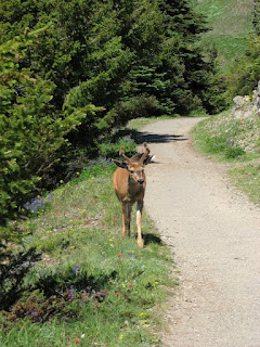
It was a clear morning so we packed up the campsite and drove over to the trailhead to walk the Dungeness Spit. It was $3 a party, but worth it with free long distance observation lookout telescopes to view the lighthouse 5 miles away on the end of the spit. You can see Mount Baker near Bellingham, WA in the distance. The entrance cost also helps preserve the Dungeness National Wildlife Refuge. There was a deer wandering the land before the beach. The Dungeness Spit is the world’s longest natural sand spit. It has sand beach, driftwood, tideflats, and abundant wildlife.
There were more banana slugs on this trail. That’s at least 5 ½” long.
We didn’t walk far down the beach. It is 11 miles round-trip to go all the way to the lighthouse. Since it is, in theory, the same view for miles, we chose to head back and do a mountain hike.
Over the piles of driftwood is the people-free zone of the Wildlife Refuge. I’m sure this is a bird-watchers dream location.
On our drive to the mountain, we stopped by Subway to get a foot long sub for lunch on the trail.
Chance has now learned how to climb over the back seat of the Xterra. It seems she is terrified of more and more stuff out here, hence why we now call her Miss Priss. I’ll give her that ferry rides and bridges are scary, but now tunnels?!? Driving up to Hurricane Ridge she climbed over the seat to shake on the pile of leftover firewood. If we’re not careful, her frightful fits are going to cause a car accident one day.
A lot of the snow had melted since July 3rd when we were last at Hurricane Ridge. It also seemed a little clearer this time too. We could see the Cascades beyond all the way in Canada.
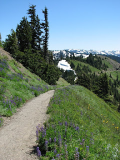
It is so green here with stark white snow on the north side of the slopes. I probably took a picture of the same view several times because I was amazed by its beauty every 30 seconds. The wildflowers were all over.
Apparently the deer don’t just hang out grazing on the mountainside of Hurricane Ridge. They roam all over the trail to Hurricane Hill. Sometimes they even follow you down the path.
There are also marmots, which are virtually large ground squirrels. The Olympic marmots are found in the alpine meadows of Olympic Peninsula slopes. They hibernate from September-May. This one even posed for me to snap a picture before proceeding to feed on the grasses. We had heard a noise earlier similar to croaking frogs or katydids. Apparently it was the marmot making a call to alert other marmots of predators. We hoped there wasn’t a bear too close to where we were.
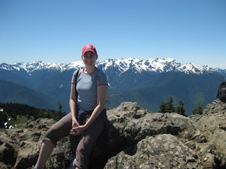
We finally made it on top of Hurricane Hill. From here we could see Port Angeles, Strait of Juan de Fuca, the San Juan Islands, Victoria on Vancouver Island, Canada beyond and Mount Baker in the Cascades.
And time to capture us in this beautiful setting...
On our hike back down Hurricane Hill, people pointed out a black bear probably 500’ down the mountain. My 12x zoom couldn’t get a clear picture, but I’m glad there was that much distance between us. We saw the wildlife we were hoping to see: bears and marmots.
This is the best hike this time of the year with the wildflowers in bloom.
Here’s a video of half-way up through the hill hike to get an idea of the panoramic view.
Joe quickly grabbed an ice cream cone from an extremely popular shop in downtown Kingston. We made the 6pm ferry, not too much later than our initial plan of 4pm. We could see the downtown Seattle skyline and the faint outline of Mount Rainier from the ferry.


No comments:
Post a Comment